
File:New Orleans USACE-17th Canal-A-09-04-05 0004.JPG

File originale (3 008 × 2 000 pixel, dimensione del file: 1,49 MB, tipo MIME: image/jpeg)
| Questo file e la sua pagina di descrizione (discussione · modifica) si trovano su Wikimedia Commons (?) |
Dettagli
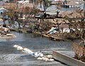
New Orleans after Hurricane Katrina:
The 17th Street Canal stretches southward, the boundry between Jefferson and Orleans Parishes in Louisiana. This aerial photo was taken Sunday, September 4, 2005. The bridge in the foreground (The Old Hammond Highway Bridge, undergoing a rebuilding before the storm) enabled Army Corps of Engineers contracts to drive sheet piling to close off the canal from Lake Ponchartrain. The Lake Pontchartrain end of the Canal is just over block distant off the lower left edge of the photo. Looking down the canal the breach into Orleans Parish is visible. The skyline of the New Orleans Central Business District lies in the distance. In the front center left, the pilings are all that remain of locally famous Sid-Mar's Seafood Restaurant, destroyed by the storm. (U.S. Army Corps of Engineers photo by Alan Dooley)
http://www.usace.army.mil/katrina-images/NO-A-09-04-05_0004.JPG
Related images include
-
 Blackhawk helicopter delivering sandbag. Pattern of sandbags is similar to this image.
 -
 Sheet pile material.


Licenza
Questo file multimediale è stato realizzato da un soldato o da un dipendente dell'Esercito degli Stati Uniti durante il suo servizio. Essendo un'opera del governo federale statunitense, il file è nel pubblico dominio.
|
 |
Cronologia del file
Fare clic su un gruppo data/ora per vedere il file come si presentava nel momento indicato.
| Data/Ora | Miniatura | Dimensioni | Utente | Commento | |
|---|---|---|---|---|---|
| attuale | 11:23, 9 set 2005 | | 3 008 × 2 000 (1,49 MB) | SEWilco | The 17th Street Canal stretches southward between Jefferson and Orleans Parishes in this aerial photo taken Sunday, September 4. The uncompleted bridge in the foreground enabled Corps of Engineers contracts to drive sheet piling to close off the canal fr |
Utilizzo del file
La seguente pagina usa questo file:
Utilizzo globale del file
Anche i seguenti wiki usano questo file:
- Usato nelle seguenti pagine di en.wikipedia.org:
- Usato nelle seguenti pagine di en.wikinews.org:
- Usato nelle seguenti pagine di es.wikipedia.org:
- Usato nelle seguenti pagine di ja.wikipedia.org: