
File:2013 Woolwich attack map.PNG
Non sono disponibili versioni a risoluzione più elevata.
2013_Woolwich_attack_map.PNG (709 × 556 pixel, dimensione del file: 112 KB, tipo MIME: image/png)
| Questo file e la sua pagina di descrizione (discussione · modifica) si trovano su Wikimedia Commons (?) |
Dettagli
| Descrizione |
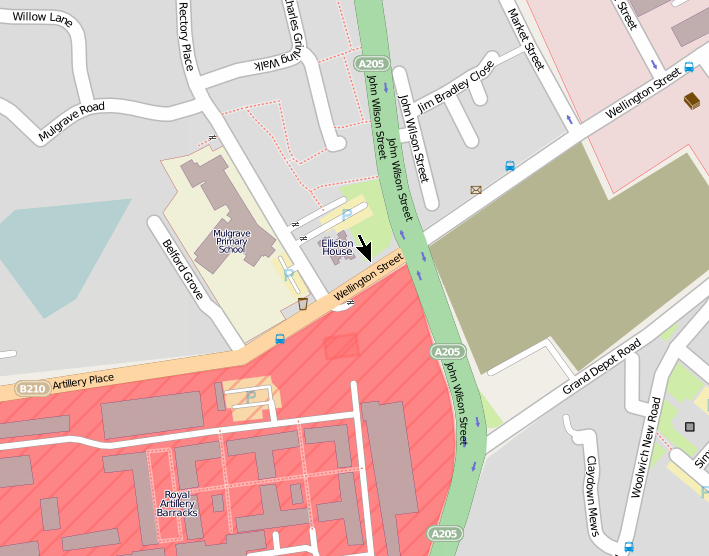
 The tower block on the right is Elliston House. English: Location of 2013 Woolwich attack, created using OpenStreetMap data The location of the incident is marked with an arrow in the centre. Elliston House is a tower block. The incident took place in Wellington Street near the junction with John Wilson Street. The site of the attack is on the perimeter of the Royal Artillery Barracks.The image on the right shows Elliston House, and the road sign into which the car crashed during the attack. Map co-ordinates: 51°29′19″N 0°03′45″E / 51.4885°N 0.06255°E Google Street View is here. |
| Data | |
| Fonte | Opera propria |
| Autore | Ianmacm |
Licenza
| This work contains information from OpenStreetMap, which is made available under the Open Database License (ODbL).
The ODbL does not require any particular license for maps produced from ODbL data. Prior to 1 August 2020, map tiles produced by the OpenStreetMap Foundation were licensed under the CC-BY-SA-2.0 license. Maps produced by other people may be subject to other licences. |
Questo file è disponibile in base alla licenza Creative Commons Attribuzione-Condividi allo stesso modo 3.0 Unported
- Tu sei libero:
- di condividere – di copiare, distribuire e trasmettere quest'opera
- di modificare – di adattare l'opera
- Alle seguenti condizioni:
- attribuzione – Devi fornire i crediti appropriati, un collegamento alla licenza e indicare se sono state apportate modifiche. Puoi farlo in qualsiasi modo ragionevole, ma non in alcun modo che suggerisca che il licenziante approvi te o il tuo uso.
- condividi allo stesso modo – Se remixi, trasformi o sviluppi il materiale, devi distribuire i tuoi contributi in base alla stessa licenza o compatibile all'originale.
Cronologia del file
Fare clic su un gruppo data/ora per vedere il file come si presentava nel momento indicato.
| Data/Ora | Miniatura | Dimensioni | Utente | Commento | |
|---|---|---|---|---|---|
| attuale | 07:50, 26 mag 2013 | | 709 × 556 (112 KB) | Ianmacm | place scene of incident and arrow at centre of image, per talk page request |
| 19:44, 25 mag 2013 |  | 684 × 566 (84 KB) | Ianmacm | larger arrow per talk page request | |
| 09:35, 25 mag 2013 |  | 684 × 566 (83 KB) | Ianmacm | with arrow marking location of the incident, per talk page request | |
| 19:52, 23 mag 2013 |  | 686 × 568 (107 KB) | Ianmacm | better crop, try again, did not seem to upload correctly the last time | |
| 19:42, 23 mag 2013 |  | 686 × 568 (107 KB) | Ianmacm | better crop | |
| 16:05, 23 mag 2013 |  | 702 × 472 (95 KB) | Ianmacm | User created page with UploadWizard |
Utilizzo del file
La seguente pagina usa questo file:
Utilizzo globale del file
Anche i seguenti wiki usano questo file:
- Usato nelle seguenti pagine di de.wikipedia.org:
- Usato nelle seguenti pagine di en.wikipedia.org:
- Usato nelle seguenti pagine di es.wikipedia.org:
- Usato nelle seguenti pagine di incubator.wikimedia.org:
- Usato nelle seguenti pagine di zh-yue.wikipedia.org:
- Usato nelle seguenti pagine di zh.wikipedia.org: